![]()
![]()
![]()
![]()
28.04.2022

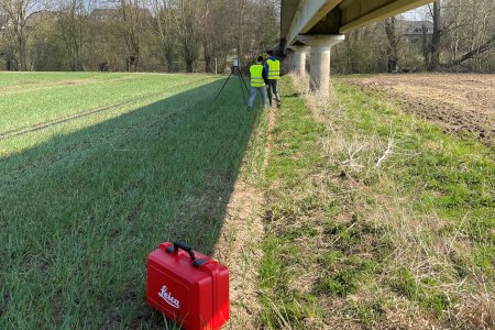
With the help of a laser scanner, we recently measured some bridges in Münster. During the exchange of experiences on site, representatives of the city of Münster and partners from the RekoTi project were present at times. The technical survey was carried out by Paul Hanswillemenke and Philippe Piras. Both are student employees at the IIB. They talk about their experiences in the interview.
Can you briefly introduce yourselves at the beginning and describe what your tasks are at the chair?
Philippe: I'm Philippe, I'm studying civil engineering and I've been working at the department since last year. Originally, I assisted in the teaching of the BIM course, but now I also have some other tasks, such as research activities or other things.
Paul: I'm Paul, I'm also studying civil engineering and I started working here 1 ½ years ago, also for the teaching. In the BIM course, I am currently responsible for the new assignment for the students. Just like Philippe, I work on different tasks in several areas for different WiMis. Among other things, for example, the measuring of the bridges in Münster, where we were on site together.
How did the measuring of the bridges in Münster go? How did that work?
Paul: Basically, we took laser scans of existing bridges in Münster with the RTC360 mobile laser scanner from Leica. Among the bridges were two small farm track bridges - i.e. bridges that are primarily used for agriculture and not for normal road traffic - and one large bridge for bicycle and pedestrian traffic. The latter had a length of 170 metres.
Philippe: Several scans were necessary for each bridge. While we needed about 11-12 laser scans for each of the two small bridges, the large bridge was a completely different matter. In the end, 93 scan positions were needed to record everything, which took four hours. That's because each scan takes about 2 minutes and then there's the time for moving and aligning the laser. The length of the bridge is still the main factor.
What happens with the data afterwards? How does the evaluation work?
Philippe: The analysis of the data is mostly my job, as it will be the subject of my bachelor's thesis. In the beginning, the transfer of the scans alone takes a lot of time because of the huge amount of data, a total of 30GB was collected. Some of the points are not exactly on top of each other, so I have to adjust them manually. Basically, the bachelor's thesis should deal with the preparation of instructions on how to optimally prepare laser scans of bridges and how the subsequent evaluation functions well. It should also give advice on what to pay particular attention to and where, for example, difficulties occur. The information needed for this will come from the literature on the one hand and will be generated with the help of expert interviews on the other. These will then be combined with my own experiences and I will create such a guideline from all three data sources.
Copyright © 2022
Last update: Apr 28, 2022