![]()
![]()
![]()
![]()
24.08.2021

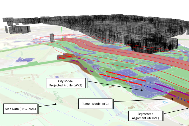
Procedure for cross-document and geometric-spatial querying for evaluating line alignments in tunneling.
The paper on the topic was presented and published at EC-ICE 2021 ("An Approach for Cross-Data Querying and Spatial Reasoning of Tunnel Alignments", pages 146-155 by Marcel Stepien, André Vonthron and Markus König). This and other interesting articles can be read in the recently published conference proceedings.
Within the project SFB 837, new methods for an interactive modeling of projects in mechanized tunneling are developed and investigated. In subproject D1, the focus is on an interactive exploration of line layouts. Variants of line layouts are modeled and evaluated on the basis of determined boundary conditions. These boundary conditions include, for example, driving dynamic factors, such as a continuous gradient and curve continuity, but also socio-cultural requirements of the surrounding area, such as the mining underpass of buildings under monument protection. A methodology for the assessment has been developed to view planning documents in an overarching way and to establish references between data sources based on their geometric and spatial relationships. For this purpose, Semantic Web technologies such as RDF and OWL are used to build a knowledge base using derived WKT profiles of the planning documents and geometrically explore them using GeoSPARQL functions.
Copyright © 2021
Last update: Sep 13, 2021